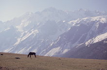
 Langtang Valley is a remote place north of Kathmandu, very close to Tibet.
Indeed you can actually see Tibet on some photos on this page, even though
I never left Nepal to take them. The official border goes along high mountain
peaks, and thus crossing the border would require serious mountaineering
skills anyway. The only conventional border post is in an adjacent valley,
and off limits for foreigners.
Langtang Valley is a remote place north of Kathmandu, very close to Tibet.
Indeed you can actually see Tibet on some photos on this page, even though
I never left Nepal to take them. The official border goes along high mountain
peaks, and thus crossing the border would require serious mountaineering
skills anyway. The only conventional border post is in an adjacent valley,
and off limits for foreigners.
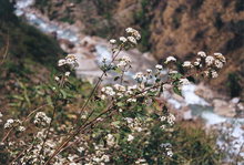
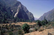
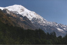
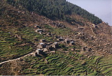 Lower Langtang is similar to other 2000-2500m hill regions in Nepal, as
you can see from the photos. The population density is lower, though, and
that came as a nice surprise to me, as I come from the smallest nation in the
world that has its own airline, beer, and football team.
There are some very pleasant fir forests in lower Langtang, between Dhunche,
Thulo Syabru, and Sing Gompa.
Lower Langtang is similar to other 2000-2500m hill regions in Nepal, as
you can see from the photos. The population density is lower, though, and
that came as a nice surprise to me, as I come from the smallest nation in the
world that has its own airline, beer, and football team.
There are some very pleasant fir forests in lower Langtang, between Dhunche,
Thulo Syabru, and Sing Gompa.
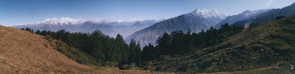
 Below you can see a 180-degree panorama over lower Langtang, taken from a hill
near Chyolangpati and Sing Gompa. Usually you don't see this kind of view
in lower Langtang, as most trails are deep in the valley. The white mountain
on the right is the giant Langtang Lirung, and Langtang valley goes along
its right hand side.
The trail to Gosainkund goes at the extreme right of the panorama (where the
hut is). The snowy peaks on the left are in Ganesh Himal, and those in the
middle are in Tibet.
Below you can see a 180-degree panorama over lower Langtang, taken from a hill
near Chyolangpati and Sing Gompa. Usually you don't see this kind of view
in lower Langtang, as most trails are deep in the valley. The white mountain
on the right is the giant Langtang Lirung, and Langtang valley goes along
its right hand side.
The trail to Gosainkund goes at the extreme right of the panorama (where the
hut is). The snowy peaks on the left are in Ganesh Himal, and those in the
middle are in Tibet.
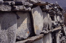
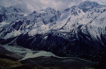
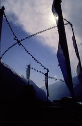 Upper Langtang is different -- very different. It's a long and wide valley
at 4000m altitude, shaped by glaciers. For 10-20km, the valley floor is
almost flat -- real flat, not Nepali flat. You can see a lot of
barren land, stone mani walls, strong winds and prayer flags.
Yaks roam the valley up to 6000m altitude (!).
Yak (Nak) cheese is available in some places.
Upper Langtang is different -- very different. It's a long and wide valley
at 4000m altitude, shaped by glaciers. For 10-20km, the valley floor is
almost flat -- real flat, not Nepali flat. You can see a lot of
barren land, stone mani walls, strong winds and prayer flags.
Yaks roam the valley up to 6000m altitude (!).
Yak (Nak) cheese is available in some places.
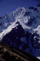
If you want to go higher than the yaks, no problem. Langtang National Park
brochures say there are 120 named and unnamed 6000m+ peaks in the area.
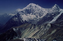
Many of them rise directly from the valley; indeed, the valley ends with
8013m Shishapangma, which is in Tibet. There are plenty of climbing
opportunities for all difficulty levels:
 Accommodation is only available up until Kyanjin Gompa, which is just at
the beginning of upper Langtang, at 3900m altitude. Above Kyanjin, there
are just some kharkas (huts) for yak herders, but no permanent
settlement, so camping in/near those kharkas is the only option.
However, trips above Kyanjin are so rewarding that for trekkers I definitely
recommend renting camping equipment from Kyanjin, and just go to
Langshisa Kharka for a few days.
Accommodation is only available up until Kyanjin Gompa, which is just at
the beginning of upper Langtang, at 3900m altitude. Above Kyanjin, there
are just some kharkas (huts) for yak herders, but no permanent
settlement, so camping in/near those kharkas is the only option.
However, trips above Kyanjin are so rewarding that for trekkers I definitely
recommend renting camping equipment from Kyanjin, and just go to
Langshisa Kharka for a few days.
 Alternatively, you can spend 4-5 days making long daytrips
out of Kyanjin; but you cannot really go farther than Langshisa Kharka
without camping, as this makes for a 15+15=30km daytrip already.
Just before Langshisa Kharka, the valley turns to the left; behind that
turn you discover a whole new world, a hidden part of the valley at the
foot of Morimoto, Langshisa Ri, and beautiful Ganchempo (all 6000-7000m).
Alternatively, you can spend 4-5 days making long daytrips
out of Kyanjin; but you cannot really go farther than Langshisa Kharka
without camping, as this makes for a 15+15=30km daytrip already.
Just before Langshisa Kharka, the valley turns to the left; behind that
turn you discover a whole new world, a hidden part of the valley at the
foot of Morimoto, Langshisa Ri, and beautiful Ganchempo (all 6000-7000m).
Unfortunately most trekkers make this classic mistake of trying to cram too
much into too little time, and they end up skipping those daytrips because
they have to be "back in Kathmandu" for a flight etc. They just trek up
to Kyanjin, climb Kyanjin Ri, and go back down the next morning! I can
honestly say that for me the real value of Langtang was in those daytrips,
and skipping these is really not the way to go.
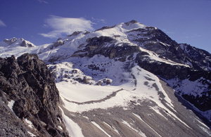
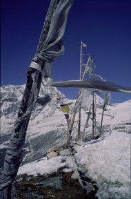
The above approach photo is taken at 5000m altitude.
Most of the climb goes on steep snow slopes, but
at times there are ca 50 vertical meters of rocks as well (the rocks were
loose). The last 15 meters to the top were climbed on a relatively exposed
rock pyramid, with 1500 meters to fall if you are really unlucky.
So although it's at the same altitude as Kala Pattar, it's not a peak for
everyone. But it's still basically a non-technical trekkers climb.
Ice axes were very useful in some places, but not essential. Equipment can
be rented in Kyanjin.
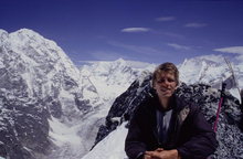 On the photo taken at the top, Shishapangma is the broad rocky peak to the right of my head.
It was the last eight-thousander to be climbed by a human.
The big pile of rock and snow on the left side of the photo is one of the
6000m+ border markers. Shalbachum Glacier is down below. The exhausted
fellow on the right is me, face burnt by the sun, lips torn by the wind.
On the photo taken at the top, Shishapangma is the broad rocky peak to the right of my head.
It was the last eight-thousander to be climbed by a human.
The big pile of rock and snow on the left side of the photo is one of the
6000m+ border markers. Shalbachum Glacier is down below. The exhausted
fellow on the right is me, face burnt by the sun, lips torn by the wind.
| Return to my homepage | Go on to Gosainkund and Helambu |