 1989 was a nice year for the 17-year-old me. I got to see
Siberia, and Central Asia as well.
1989 was a nice year for the 17-year-old me. I got to see
Siberia, and Central Asia as well.
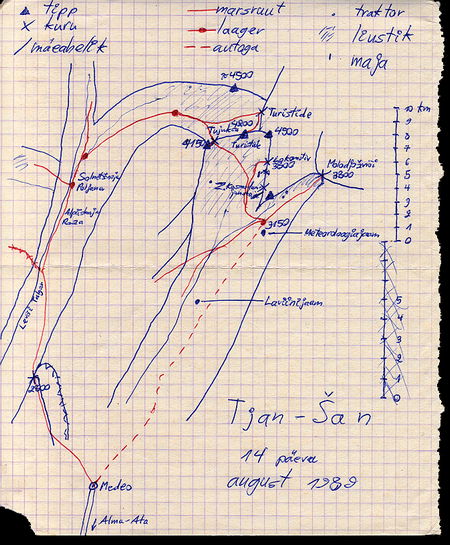
In Central Asia we were hiking in Tien-Shan mountains (Heavenly Mountains in Chinese). It's a fairly high mountain system, with highest peaks towering above 7000m. However in all our modesty we limited ourselves to the 4200 meters of Tujuk-Su peak.
We started off near Alma-Ata (Almaty), which was until recently the capital of Kazakhstan, before passing the honour to Akmola in the north. Alma-Ata is in the plains, the vast steppes of Kazakhstan. I got a glimpse of the steppe when the plane landed at Karaganda during sunset. This moment was more beautiful than I am able to describe here -- the sun was red, the sky was red, and the steppe was red. There was nothing else, all the way to the horizon. It was like the sea -- nothing is blocking your view all the way until the Earth's curvature does its job. It's a rather sparsely populated area, which obviously had its share of Soviet military, secret factories, and also Baikonur, the home of Soviet space programme.
From Alma-Ata we moved south to the mountains. Most of northern
Tien-Shan seems to be a moraine/glacier desert above 3000m or so;
they say central Tien-Shan is more varied. Anyway this did not bother us too
much, and the scenery can certainly be compared even to the Himalayas.
Unfortunately I don't have any nice
photos from this trip; I can only point you to
another site with more stuff
on Tien-Shan and other mountains in that part of the world.
Central Asia is a place where I want to return some day.